Does the East Side Coastal Resiliency incorporate East Village subterranean streams? Mapmaker Wendy Brawer wrote this in February 2019. The questions she asks have not been answered by the city as of the 7/16/20 CB3 Parks meeting. The consequences could be dire.
I am haunted by the underground rivers I see in historical maps of Manhattan.
I’m especially drawn to the mythic maze of subterranean streams under the East Village. These are left off the City’s public visualizations of the East Side Coastal Resiliency project (ESCR) project that is meant to protect our community from flooding. This is a potentially disastrous oversight that will affect my neighborhood as the sea level rises and climate change delivers increasingly intense storms.

Subterranean Streams? What subterranean streams?
Responding to my questions at public meetings, the Department of Environmental Protection says these subterranean streams are not under their jurisdiction, and they don’t know where they are.
This year, test bores for rain gardens are being made in the same area for the Gardens Rising project, and there are reports on progress mapping the underground. Can’t these shed light for developing the ESCR, too?
Why doesn’t the City have a Deputy Mayor for Infrastructure so agencies, adjacent projects and geography can be coordinated?
Instructive Historical Maps
Look at some of the maps I’ve collected as background and inspiration for my work over the last 25 years. I map sustainable living resources including community gardens, greenmarkets, bicycling and solar sites. Since 2001, I’ve often included Manhattan’s historic shoreline to highlight how humans have impacted this “small island nation” and to foreshadow changes to come.
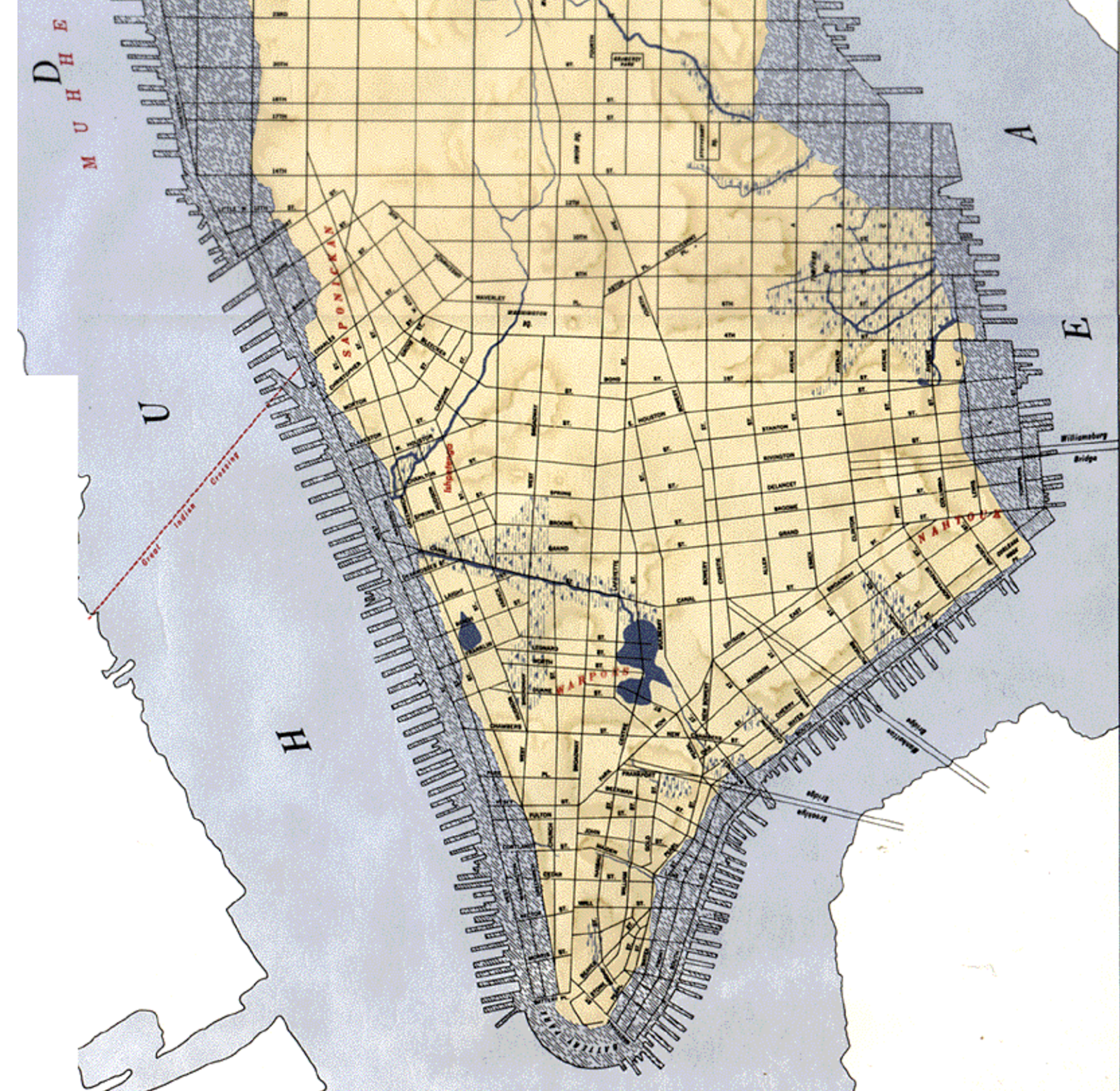
Townsend MacCoun’s map of Manhattan “at the time of its discovery” includes Native American villages (in red) and topography from 1609 with water-courses, marshes and shore line, overlaid with the 1867 street grid and harbor. Full of surprises, it was made for underpinning engineers, and still provides crucial knowledge for erecting new buildings and infrastructure.
In this map, the East Village looked especially vulnerable, with subterranean rivers and tidal salt marshes extending nearly to 1st Avenue. The book “The Archaeology of Home” tells how the land was extended and filled in, and how docks and shipyards soon ringed the shore. Even today, people in the community know that willow trees are indicators that these ancient waterways still flow. This year, test bores for rain gardens are being made in the same area for the Gardens Rising project, and there are reports on progress mapping the underground. Can’t these shed light for developing the ESCR, too?
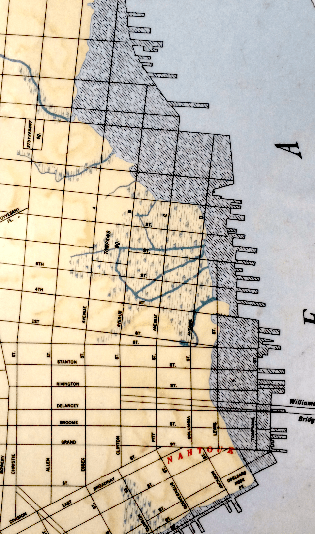
Check out the Viele Map, dated 1865. Use the link to see a zoomable version of the map with amazing details of the land under and around the 58 acres of today’s East River Park. The orange is landfill and piers, with the green being the extent of the original shoreline. Land and water continually transform one another. Climate change is accelerating that evolution. No one really knows what’s coming, or when. It’s clear though, that these maps provide information critical to the planning of the ESCR.
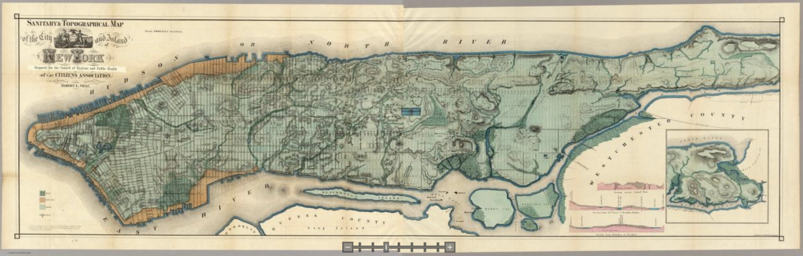
The Viele Map is properly known as the Sanitary & Topographical Map of the City and Island of New York. Use the slider at bottom center to zoom in and lay bare geographical vulnerabilities.
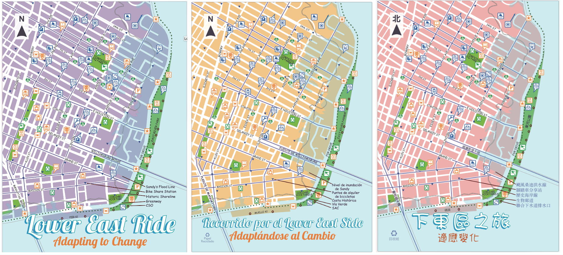
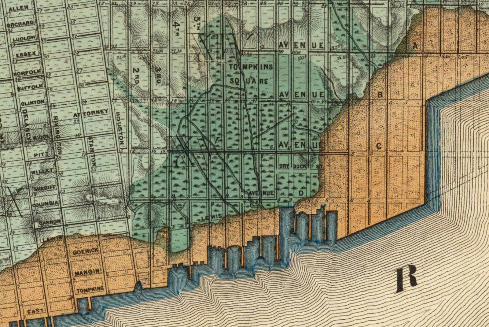
As a 30 year resident and as a mapmaker, I’m also sharing an example from my professional work with Green Map System. This post-Sandy Green Map is the Adapting to Change, Lower East Ride edition. Produced in Spanish, Chinese and English in 2013 to encourage more cycling, this map includes both the super storm’s high water mark and the original shoreline, as well as the combined sewer outfalls in East River Park.
As major changes to the geography are being prepared, I ask the City, why don’t your ESCR and sewer plans include these subterranean streams?
I have taken copies of the Viele Map to City Council Hearings, presented it to the Delrtares consultant, and talked about it for years at CB 3 meetings, LUNGS, East River Alliance & East River Action Meetings. The recent sink hole that graced the 8th St. & Ave B entrance of Tompkins Sq. Park for over 2 years and was shoddily repaired appeared above one of the streams shown on the Viele map. East 6th St and Ave C has had continued issues with sink holes over the years. It is amazing that in NYC the City seems to think that streams just go away when filled in or are incorporated into storm sewers-wonder if the ever heard of “meandering streams”? The LES was the home to NYC’s first water system. The many streams that undercut the neighborhood were used to provide water for Lower Manhattan in the 1820’s-30’s through a piping system that originated on E. 13th st. and 3rd Ave-The FDNY fire house sits at the site of the first pumping station. Why is the City continuing to ignore the presence and effect that these streams have on our built environment? They did not vanish but have frequently been repurposed as storm sewers that flow into the East River. The current ESCR proposal to build a solid cement sea wall from the bed of the river will not allow these streams to empty into the river. They would have to be incorporated into the parallel conveyance drainage system that DDC is proposing. Yet when asked directly at CB 3 Parks Committee meetings, DDC engineers have told me that they are not dealing with the streams.
In a follow up to a conversation with City Council Member Carlina Rivera, I wrote this (as one of several questions). Copies were sent to CCMs Keith Powers and Margaret Chin and to the Department of Design and Construction, and the Community Advisory Group,
Subterranean Streams
In our conversation, we also discussed the underground streams and marshes throughout the East Village and whether they have been incorporated into the ESCR drainage plan. It is unclear if the city has reliable information there.
You pointed me to the answer DDC gave in a Tweet, and I looked up the reference. Here’s what it said: “While historically there may have been streams in this area, they have all been filled as the area was developed and these historic wetlands and streams no longer exist…”
One resident pointed out that you could hear the water rushing if you were near the sinkhole that was at 9th and Ave. B for a couple of years (recently repaired). That stream exists. It’s a subterranean river. Gardeners have also uncovered moving water five to six feet below the surface.
The DDC also noted, “The existing sewer system would also be modified with parallel conveyance and upsized sewers to increase its capacity to convey wet-weather flows to Manhattan Pump Station during a design storm event, thereby reducing the risk of flooding and sewer backups within the drainage protected area.”
https://www1.nyc.gov/assets/escr/downloads/pdf/SANDRESM1-Joint-ROD-and-Findings-Statement-12-6-19.pdf
It is unclear if those streams are connected to the existing sewer system. Will these waterways be hooked into the parallel conveyance? If not, it could be blocked by the new lines, and the East Village would be much worse off after a big storm.
Subterranean Streams Question: Could it be arranged for the people who know about the streams and live in the neighborhood to speak with those who work on this aspect? These local experts could be either reassured or provide valuable information that could save a lot of flooding trouble.
from Carolyn Ratcliffe: My major concern throughout this process is how the City is going to address the underlying problems of underground streams moving through soils composed of mud, peat, rubble & fill resting on top of a thin layer of shale that is 40’ deep with bedrock between 150’-170’ deep. There is an insert in the lower right hand corner of the Viele map that gives a graphic depiction of 3 areas of Manhattan showing the depth of gneiss, mud and soil where the glacier carved out the trough that the LES sits on-the area between Hoboken & Brooklyn. It shows the bed of East River mostly sitting on gneiss except by its western shore which is soil-the area that the proposed ESCR sea wall would be seated.
This area of the LES/East Village was a salt water marsh when the Dutch arrived. The area was covered with brackish water from the East River at high tide all the way to what is now Ave A by TOMPKINS Sq. Park. The original Dutch land grants were given with the caveat that owners must drain the swamps on their property to maintain ownership. The way the streams are shown on the Viele Map reflect how some streams were channeled to drain into the East River. Just because they tried to turn the streams into brick lined storm sewers does not mean they will always behave the way people want them to. Really appreciate Wendy’s maps and article on ERPA website. Just wish elected officials would read & digest the information to understand why we are concerned about the current ESCR plan.
Great to see these details by Carolyn and Pat. This history should be informing stormwater planning, I agree.
While the ESCR team has yet to show how the plan will protect these areas, I’m encouraging concerned residents and our elected representatives to check the highly respected Welikia map – https://welikia.org/m-map.php
Zoom into the East Village (10009) and the map outlines small sections – click Landscape and scroll down, many of the sections say Tidal Creek –
You can see the elevation, elevation and underlying bedrock for each section. Recently, the ESCR team has called these subterranean streams ‘groundwater’. Here are definitions of both – and the questions remain about how this water will be able to drain after heavy rains, storm surges, and all that climate change will bring.
https://en.wikipedia.org/wiki/Tidal_creek
https://en.wikipedia.org/wiki/Groundwater
Here is the Big U Plan – go to p 196 and see what it included to help mitigate these issues, and realize, 8 years later, none of it is in place in the East Village areas where Sandy’s floodwaters rolled down Avenue C and surrounding blocks. http://www.rebuildbydesign.org/data/files/675.pdf