Schedules Unkept, East River Park, a 21st Century History
The timeline below outlines plans and building in East River Park. Following the timeline are links to plans over the years.
2001-2011 a slide show of the painful 10-year closure of the waterfront promenade. Rebuilding was promised as a two year project starting in 2005 (before that, starting July, 2001, the waterfront was just flat closed because of damage to waterfront pilings with no plans to fix the bulkheads) by Pat Arnow: https://patarnow.zenfolio.com/p249576553
2005 article in Gotham Gazette about plans–at last–to rebuild closed promenade in East River Park.
https://www.gothamgazette.com/index.php/development/3011-east-river-access-from-the-lower-east-side
2006 article in Gotham Gazette that includes information about stalled construction of promenade rebuilding. https://www.gothamgazette.com/development/3371-waterfront-in-fits-and-starts-and-stops
WNYC article about rebuilding over 10 years. Park Rehab 10 Years in the Making by Matthew Scheurman: https://www.wnyc.org/story/98594-park-rehab-10-years-making/
2012 East River Blueway Plan developed with community input for protection and resiliency.
2012 Hurricane Sandy strikes New York City. Sandy leaves dozens dead. The storm’s more than nine feet of storm surge from the East River causes extensive damage in the Lower East Side.
2013 “How Hurricane Sandy flooded New York back to its 17th century shape as it inundated 400 years of reclaimed land .” A good history from the 17th century onward of NYC landfill that widened Lower Manhattan and how that was all flooded—and Mayor Bloomberg’s proposal to protect that coastline. In the British DailyMail.com of all places.
2013 President Obama launches a national design competition, Rebuild by Design, to develop projects to prepare for future disasters. Urban planners, architects and community groups come together to develop a coastal protection plan, known as the BIG U, to reduce the risk of flooding caused by climate-change related storm surge and rising sea levels in Lower Manhattan.
2014 US Department of Housing and Urban Development (HUD) selects the BIG U as a winner of the competition. NYC and HUD allocate $335 million to build the first section of the BIG from Montgomery to East 25th streets, calling it the East Side Coastal Resiliency (ESCR) project.
2014 –2017 The Lower East Side community engages in extensive planning meetings with NYC agencies to redesign the waterfront parkland from Montgomery to East 25th streets. Community Boards 3 and 6 set up a task force, and together with local stakeholders, engage in more than a dozen community engagement sessions to provide comments and feedback on the design. During that time, the City committed additional $425 million to the first section, for a total of $760 million. The proposed design includes a bermed flood barrier on the western part of the park, along the FDR highway, and intends to use East River Park to absorb storm surge water.
2018 March: Community Board 3 commits to endorsing the design for the East Side Coastal Resiliency project plan if certain adjustments are made, including solar and wind lighting, and more education about resiliency and climate change.
October 2018: After four years of planning, the Mayor’s Office announces that they are scrapping the approved design for the section of the East River Coastal Resiliency project from Montgomery Street to 14th Street, to install a flood wall along the water’s edge. The new plan is to destroy the existing park and build a levee on 8-10 feet of landfill from around Grand Street to 14th Street. The cost for the project is $1.45 Billion. Construction is planned for spring 2020, completion by 2023, closing East River Park for the duration of construction.
November 2019: City Council approves the East Side Coastal Resiliency plan. The city promises mitigation (alternate park resources), phased construction, communications, and transparency.
October 2020: Despite the pandemic in which open spaces are at a premium and severe budget shortfalls, the city proceeds as planned. However, due to other complications, start of construction is delayed until 2021.
January 2021: Responding to a Freedom of Information Law (FOIL) request, NYC denies existence of Value Engineering Report that it had originally cited as the reason for the change in plans and the burial of East River Park.
March 2021: After five delays, bids finally in for the East Side Coastal Resiliency project. The low bid (of the two submitted) for will put the project $73 million over the $1.45 billion budget (not including the “parallel conveyance” enhanced sewer system part of the project).
March 2021: After an appeal of the FOIL request, NYC releases a heavily redacted Value Engineering Study. After another appeal and a lawsuit, less redacted versions of the study reveal alternatives to the current East Side Coastal Resiliency plan.
July 2021: After NYC accepts low bid, the higher bidder (Tully) sues the city because IPC Partners failed to fulfill bid requirements. Comptroller Scott Stringer does not sign the contract, but sends questions to the Department of Design and Construction, which has 30 days to respond. Mayor de Blasio overrides the Comptroller and signs. Notice to Proceed issued in August.
October 2021: The compost yard is removed in preparation for a lawn to be used as “mitigation” during the project. Construction on ESCR to begin Nov. 1, 2021.
December 2021: Amphitheater seating is bulldozed and many of the surrounding 82-year-old oaks are cut down, in what looks like a strategy to complete as much destruction as quickly as possible.
2022-2025: Sixty percent of East River Park razed, East Side Coastal Resiliency work ongoing. Northern section of park remains open.
May 2025: The section of park south of the Williamsburg Bridge opens. It includes much-expanded tennis courts, basketball courts, two artificial turf playing fields, a barbeque/picnic area under the bridge, a wide promenade, two lawns and an amphitheater. There is no shade, though many saplings might provide some in coming years. The fate of the old fireboat house, which was supposed to be flood-protected remained uncertain. New footbridges from Corlears Hook Park and by the Williamsburg Bridge, go over the FDR Drive to connect to the Lower East Side.
May 2025: The northern section of East River Park is closed and demolished. Pile driving for the parallel conveyance (extra sewer capacity) on the city side of the FDR is ongoing. Building of compost yard/Lower East Side Ecology Center structures ongoing. Unforeseen complications (more messy rubble as landfill than expected for instance) delays schedule by a year. Northern end of park now scheduled to be opened in the fall of 2027.
Documents and documentation
Below are links to documents, reports and news stories. Here is where you can find facts and figures and much more:
Our East River Park
A slide show of the wonders of East River Park in recent years and what we will lose. https://patarnow.zenfolio.com/p313418955
Here’s a post with an interesting historical map of Corlears Hook Park/East River Park. http://parkodyssey.blogspot.com/2018/10/corlears-hook-park.html
This is a one-pager that explains the history of the Amphitheater and what the Lower East Side is losing with the destruction of this cultural icon: https://documentcloud.adobe.com/link/track?uri=urn:aaid:scds:US:bbc28f9a-824c-4f3e-b314-903bf9c4c190
Plans as they were and are

A People’s Plan For the East River Waterfront
GOLES–Good Old Lower East Side–helped start LES Ready!, the longterm recovery group that formed in response to Sandy. Out of their grassroots organizing, the community was able to engage the Rebuild by Design process. Many other organizations contributed to the People’s Plan for the LES Waterfront even before Sandy. Check out this thoughtful and detailed report. It’s a history, survey, and recommendations.
https://caaav.org/publications/PeoplePlanFINAL.pdf
East river Blueway Plan, 2012
East River Blueway Plan, 2012
Look at this. You’ll cry when you see how beautifully it could have been done if we’d adopted these 2012 plans. https://www.wxystudio.com/projects/urban_design/east_river_blueway_plan
Further resources compiled by Kendra Krueger:
Community Design Plan
Description: GOLES–Good Old Lower East Side–helped start LES Ready!, the longterm recovery group that formed in response to Sandy. Out of their grassroots organizing, the community was able to engage the Rebuild by Design process. Many other organizations contributed to the People’s Plan for the LES Waterfront even before Sandy. Check out this thoughtful and detailed report. It’s a history, survey, and recommendations.
https://caaav.org/publications/PeoplePlanFINAL.pdf
Rebuild by Design ‘The Big U’ Design Report
http://www.rebuildbydesign.org/data/files/675.pdf
Master Plan for Pier 42, 2014
“Pier 42 uses a combination of newly created soft shoreline edge and an inboard ridge to dissipate wave action and protect against both flooding and future sea level rise. The park will place mechanical systems and small park buildings above the new 100 year flood line and seeks to use solar-powered lighting to eliminate any electrical conduit from vulnerability. All plant material and hardscape finishes within the flood zone will be tolerant of period inundation.” – Signe Nielsen, Principal, Mathews Nielsen
Pier 42 Park Project Lands $19 Million More In Funding, Lower East Side, 2016,
Back in 2012, the Lower Manhattan Development Corporation (LMDC) secured $16 million in funding to build Pier 42 park, located between FDR Drive and the East River on the Lower East Side. Curbed reports the project has now received more complete financing in the form of $12 million more from the LMDC in addition to $7 million via settlement funds recently distributed by Gov. Andrew Cuomo. Once complete, the public space will include landscaped lawns and gardens, an esplanade, a bike path, playgrounds/play areas, a concession station, and a pavilion. Mathews Nielsen Landscape Architects is designing. Phase one, which largely focuses on remediating and pedestrianizing the pier, is expected to begin in 2017. A former cargo warehouse must first be demolished.
Fact Sheet: De Blasio Administration Announces Faster, Updated Plan for East Side Coastal Resiliency Project
September 28, 2018
“The adoption of the new design follows a value engineering study performed earlier this year and a review of the project by a panel of experts with experience from around the nation.” We are unable to locate this value engineering study. Because it’s a myth?
NYCHA Recovery and Resiliency Plans
Description: NYCHA’s own flood protection plan, separate from ESCR
https://www1.nyc.gov/site/nycha/about/recovery-resiliency.page
History of Stuyvesant Cove Park from the Glaciers to Native Plant haven to probable flood wall.
By Eli Sargent, Fall 2018
What is in that fill that is going to be dug up?
“Preserving community while expanding resiliency at New York City’s East River Park,”
by Carter Strickland, James Lima, and Amy Chester, Parks and Recreation Magazine, May 2019
All about the stewardship model of maintaining park. That will be useful someday in the distant future when there is a new park. Includes an article about the artificial turf and the heat island effect (we’re going to get lots more artifiial turf in the new East River Park when it is rebuilt someday)
Design and Planning for Flood Resiliency: Guidelines for NYC Parks
Includes this advice on artificial turf: “New synthetic turf or track surfacing is generally not recommended within or near the 100-year Zone VE, especially in areas adjacent to open ocean that are most vulnerable to high velocity wave action and storm surge.”
“Natural turf is a resilient surface for the floodplain. Grass can survive even under prolonged inundation. The success of this surface in the floodplain may depend on how well the subsoil drains and can withstand erosion. In general, natural turf sports fields requiremore maintenance (e.g., mowing, fertilizing, etc.) compared with synthetic turf. Natural turf under heavy athletic use will require more maintenance and may be more susceptible to erosion during storm events. Natural turf is, however, inexpensive to restore and is better to use in floodplain parks than many costlier materials.
… Use naturalturf for passive and active recreation in the floodplain.”
Berms aren’t enough: NYC shifts course on “Big U” Resiliency Plan
Jared Green, June 20, 2019, The Dirt
To protect against future super storms and long-term sea level rise, New York City proposed creating a set of landscaped berms around the southern tip of Manhattan, a plan deemed the “Big U.” The city secured some $330 million from the U.S. department of housing and urban development (HUD)’s Rebuild by Design competition in 2014 to kick start the project. After four years of intensive community engagement, the city suddenly switched gears last fall, throwing out those plans in favor of raising the first proposed segment of the Big U — the waterfront park between 25th street and Montgomery Street on the east side — by 10 feet. Instead of berms, the existing 60-acre East River Park will be buried under landfill and its new higher edge will become a wall holding back the East River, which is expected to rise with the Altantic Ocean by 2.5 feet by 2050.
David said the “park will be effective for a period of time, and many lives will be improved.” But the city and team have really only planned for 2050. “Things are changing rapidly. This buys us more time. There is no great solution.”
ESCR Project Background
Environmental Review documents including Draft and Final Environmental Impact Statement and Hydraulics Reports.
https://www1.nyc.gov/site/escr/about/environmental-review.page
Value Engineering Study
The city claimed there was no Value Engineering Report, even though that was the reason cited in the Mayor’s statement for the 2018 change that would completely destroy East River Park. After we filed a Freedom of Information Law (FOIL) request and appeal, the study finally turned up in 2021. It was heavily redacted, but gradually, the city removed some of the blackened out portions, and you can see alternatives to the destruction of the entire park and building of a 20th century style levee.
The 347-page Value Engineering Study for the Office of Management and Budget is available here, heavily redacted: https://www1.nyc.gov/assets/escr/downloads/pdf/ESCR-Value-Engineering-Study-Preliminary-Report-2018.pdf
Here’s the Value Engineering Study after we appealed to the court for an un-redacted report. This has just a few blacked-out sections: https://www.nyc.gov/assets/escr/downloads/pdf/escr_value_engineering_study_preliminary_report_2018.pdf
The 31-page Report of Findings is available here:
https://www1.nyc.gov/assets/escr/downloads/pdf/ESCR-Elevated-Park-Alternative-Feasibility-Analysis-2018.pdf
Here is the Value Engineering Report FOIL and reply 2021. It seemed to be a myth that it existed. And then it turned up.
Tree replacement analysis
FEMA took out 297 large trees at Baruch (NYCHA housing) for flood protection construction. Nearly a thousand would be lost with the razing of East River Park. When a street tree resolution passed in Feb 2019, the city promised it would plant 1000 street trees in the area adjacent to East River Park. But the city then included already requested trees–essentially the trees that would have been planted anyway, not ones to mitigate the loss of trees in East River Park, much less the ones lost to at NYCHA. There was more, as outlined in a letter to Minelly de Coo in the Mayor’s office and Councilmembers Rivera, Chin and Powers, 11/19 from Wendy Brawer:
…as you know I am concerned with Heat Island Effect (#1 threat in the City’s Climate Resiliency Design Guidelines). The park is losing nearly 1,000 trees. Without their mitigating effects, residents will become overheated and will struggle to pay for air conditioning, the powering of which will generate more Greenhouse Gases. Health was not a criteria in the DEIS (even Con Edison pointed out that Children’s Health was left out) so as a matter of equity, justice and risk, I ask you to work with nature, not against it.
Dr. Amy Berkov has calculated that as per the ESCR’s FEIS, East River Park will lose 973 trees with a cumulative DBH of 12,740 inches. To meet the “caliper inch” replacement criterion in the NYC Rules Governing Tree Replacement, the ESCR should plant at least 4,247 three inch saplings as follows: 1,815 trees in the project zone, 1000 street trees in each of CB3 and CB6, plus an additional 432 3 inch saplings on NYCHA campuses, in parks (4,247 x 3 inches = 12,740). This is financially feasible as AG James pointed out in the DEIS that there is $32.9 million in restitution. Don’t skimp on mitigation.
East Side Coastal Resiliency Plan (ESCR Plan)
Description: The city’s current ‘preferred alternative’ plan and earlier options.
Timeline: October 2018 first presented
Website portal: https://www1.nyc.gov/site/escr/index.page
Note: When we say the city should go back to the earlier plan, we need to make a distinction. Here’s why: The original plan, community-developed plan, was closer to Alt #2 (265 trees cut) but then the City added all the amenities and the revamping of the access bridges (all that stuff to make the project more of a park purpose–see our Alienation pages) and that became Alt #3 (776 trees felled). In the EIS, the City was the one who claimed that Alt 3 was the prior plan to make it closer to the present plan so that it would weaken the number of trees difference argument among everything else.
from Amy Berkov: This was the comparison chart that I put together back when we were working on the Environmental Impact Statement (with Community-Approved gussied up into Alt 3 in the EIS).
Value Engineering Study, 2018 <https://www1.nyc.gov/assets/escr/downloads/pdf/ESCR-Value-Engineering-Study-Preliminary-Report-2018.pdf>
Elevated Park Alternative Feasibility Analysis
<https://www1.nyc.gov/assets/escr/downloads/pdf/ESCR-Elevated-Park-Alternative-Feasibility-Analysis-2018.pdf>.
January 2019 ESCR Plan presentation
Hoylman and Elected Officials Demand Transparency, Community Input at Council Hearing on East Side Coastal Resiliency Project
BRAD HOYLMAN , January 23, 2019
Furthermore, under the current plan, the demolition of East River Park would include the full and irreversible destruction of an entire ecosystem that contains nearly 400 species and numerous trees. We respectfully request that alternatives be proposed so that an entire ecosystem is not obliterated.
Plan details from From September 17, 2019, Hearing:
https://www1.nyc.gov/assets/escr/downloads/pdf/ESCR-Final-SAPA-Hearing-Presentation-2019.09.17.pdf
- Download Board Materials
- Download Animation of Floodgates and Drainage
- Download Animation of Fly Through
- Download Animation of Bike Through
Environmental Impact Statement
Description: The FEIS includes a detailed project description and an assessment of environmental impacts, including direct, indirect, and cumulative effects, associated with a No Action Alternative, Preferred Alternative, and three other With Action Alternatives, and a response to comments on the Draft Environmental Impact Statement.
August 2019
Website: https://www1.nyc.gov/site/escr/progress/environmental-review.page
Executive Summary:
https://www1.nyc.gov/assets/escr/downloads/pdf/FEIS/ESCR-EIS-Chapter-0.0-Executive-Summary.pdf
Final Environmental Impact Statement, Sept. 2019
Environmental Review Documents: https://www1.nyc.gov/site/escr/progress/environmental-review.page
National Environmental Policy Act, New York State Environmental Quality Review Act, and City Environmental Quality Review JOINT ROD (Record Of Decition) and FINDINGS STATEMENT, New York City Office of Management and Budget New York City Department of Parks & Recreation, December 2019.
SEQRA: https://www.dec.ny.gov/docs/permits_ej_operations_pdf/seqrhandbook.pdf
December 2019 Letter of Agreement City Council Members
JOINT ROD and FINDINGS STATEMENT, December 2019
Community Development Block Grant Disaster Recovery, Feb. 7, 2020
CDBG-DR Action Plan Responses to Public Comments
https://www1.nyc.gov/assets/cdbgdr/documents/amendments/Response_to_Public_Comments_APA_21_v1.pdf
Among the responses, here’s the rationale for demolishing the park. It’s about Traffic.
Preferred Alternative Rationale:
The shorter construction duration for the flood protection under the Preferred Alternative is primarily due to minimized construction disruption and delay along the FDR Drive (which would require temporary nighttime single-lane closures of the FDR Drive to allow construction) and reduced construction complexity related to the existing Con Edison transmission lines that run parallel to the highway along the park. Under Alternative 3, closures of the FDR Drive would need to meet requirements set forth by the New York City Department of Transportation (NYCDOT) and would limit construction to approximately six hours of single-lane closure of the FDR Drive per night.
Alienation lawsuit transcript including decision: https://iapps.courts.state.ny.us/nyscef/ViewDocument?docIndex=PgS_PLUS_lDDRZrJPCVDQQhI4zQ==
Interim Flood Protection Measures. Just NO
Here’s what NYC is doing for temporary protection in other neighborhoods: https://www1.nyc.gov/site/lmcr/progress/interim-flood-protection-measure.page
Our July 2020 Report on Office of Emergency Management NYC feasibility study of Interim Floord Protection Measures. Our followup report, Not One Sandbag, Part 2
Who lives by the Park? 2019 report
https://censusreporter.org/profiles/79500US3603809-nyc-manhattan-community-district-https://censusreporter.org/profiles/79500US3603809-nyc-manhattan-community-district-3-chinatown-lower-east-side-puma-ny/3-chinatown-lower-east-side-puma-ny/
Neighborhood Improvements Interim Recreation Update
NYC Parks, Aug. 13, 2020
How to Snoop Through Property Records Like a Reporter
“What’s being built down the block? Where does your landlord get mail? How much did your neighbor pay for that place? Answer those questions and many more with THE CITY’s document-digging guide.”
Neighborhood Interim Recreation Improvements Updates
East Side Coastal Resiliency Sept. 10, 2020
Alternate parkland sites, Baruch Bathhouse, Pier 42, etc.
https://www1.nyc.gov/assets/escr/downloads/pdf/nyc-parks-presentation-20200910.pdf
East Side Coastal Resiliency Meetings and Workshops presented by NYC from 2019-through 2020. Presentations are downloadable.
https://www1.nyc.gov/site/escr/project-updates/presentations.page
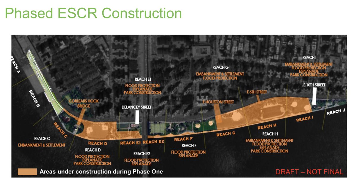
ESCR Construction Timeline
https://www1.nyc.gov/assets/escr/downloads/pdf/escr-cb3-parks-20211014.pdf
ESCR Construction Bulletins
https://www1.nyc.gov/site/escr/project-updates/construction-notices.page
ESCR website
https://www1.nyc.gov/site/escr/index.page
Presentation for the Community Advisory Group
Construction progress reports: https://www.nyc.gov/site/escr/project-updates/community-advisory-group.page
The Community Advisory Group (CAG) is an independent, community-based entity serving in an advisory role to the project team during the ESCR construction phase. The CAG will serve as an ongoing vehicle for information-sharing, bridging the community and the project team. Per the CAG guidelines, the public is invited to observe these meetings only; no questions or comments will be taken from the public during the meetings.
Visit the Community Events page for upcoming CAG meetings and links for livestreaming.
View official City responses to CAG inquiries.
Ask a question of the Department of Design and Construction (leading the ESCR project):